No products in the cart.

Free Shipping
Garmin DriveTrack™ 71 + Garmin Full Topo With Hema Maps
$869.99
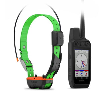
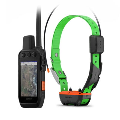
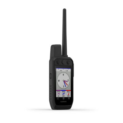
Garmin Drivetrack 71
or Zip it from $10/week with
 ⓘ
ⓘ
Description
Enhanced topographic details on your Garmin Alpha 100, Garmin Alpha 200i, Garmin Astro 430 and Garmin Drive Track 71 whether you’re in the outback or in the city. The Garmin Australia & New Zealand Topographical maps featuring Hema Maps HEMA 72K Raster and HEMA POIs provides a wide array of topographic information from terrain contours, elevations, summits to coverage of perennial and intermittent lakes, rivers and streams. in Australia and New Zealand.
- Provides terrain contours and summit points at 10 m intervals for a more detailed view of the terrain
- Contains more than 105,000 km of tracks, roads and outback trails; also displays 4WD destinations and hydrographic features: lake/river shorelines and perennial and seasonal streams
- Includes built-in DEM data with 3-D shading and route elevation profiles on compatible devices so you can estimate terrain difficulty
- Offers updated and new searchable HERE and HEMA points of interest in urban, rural and outback areas, including lodging, restaurants, homesteads, parks, shopping and camping locations
- Displays updated routable road content, by HERE, to give you turn-by-turn directions to your destination
Features:
* Works with Astro 430 or Alpha 100 (software 7.60 update required) GPS dog system to track your dogs
* Displays roads, trails and dog locations on a bright 6.95-inch high resolution display
* Includes preloaded TOPO Lite AU/NZ mapping and 1-year Birds Eye Satellite Imagery subscription
* Detailed road maps of Australia and New Zealand with free lifetime map and traffic updates
* Road map gives spoken turn-by-turn directions, plus driver alerts for sharp curves, speed changes, school zones and more
* Easy to track dogs with On road and Off road maps
* Bluetooth smartphone connect for handsfree and smart notification
* Driver Alerts and live Traffic Notifications
* 1 year warranty
| General | |
| Physical dimensions | 17.3 x 9.9 x 1.9 cm |
| Weight | 243 g |
| Battery type | rechargeable litdium-ion |
| Display type | WVGA color TFT witd white backlight |
| Display size | 6.95″ |
| Display resolution | 1024 x 600 pixels |
| Battery life | up to 1 hour |
| Memory/history | internal solid state |
| High-sensitivity receiver | Yes |
| Maps & Memory | |
| Preloaded street maps | Yes |
| Includes lifetime map updates | Yes |
| nüMaps Guarantee | Yes |
| Accepts data cards | microSD™ card (not included) |
| Custom POIs (ability to add additional points of interest) | Yes |
| Waypoints/favorites/locations | 1000 |
| Navigation Features | |
| Speaks street names | Yes |
| Voice-activated navigation (operate device witd spoken commands) | Yes |
| Traffic compatible | Yes |
| Lifetime traffic updates | Yes |
| Lane assist (guides to proper lane for navigation) | Yes |
| Junction view (displays junction signs) | Yes |
| Route avoidance (avoid highways, tolls etc.) | Yes |
| Hands-free calling | Yes |
| Speed limit indicator | Yes |
| View upcoming points of interest along route | Yes |
Share your thoughts!
Let us know what you think...
Only logged in customers who have purchased this product may leave a review. Log in now
Related products
-

Bore Snake – Shotgun 12ga
$12.49 Quick ViewAdd to cart -
 Free Shipping
Garmin Alpha 300 / TT25 Track N Train System
From: $1,978.00 Quick ViewAdd to cart -
 Free Shipping
Garmin Alpha 300i / TT25 Track N Train System built in inReach®
From: $2,128.00 Quick ViewAdd to cart -
Garmin Alpha 300 Handheld Only
$1,349.00 Quick ViewAdd to cart


What others are saying
There are no contributions yet.